
Sebastian, Grant, Micco, Barefoot Bay, Fellsmere, and Vero Beach are still under a hurricane warning. A storm surge warning is also in effect.
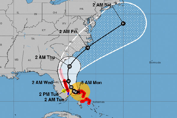
The projected path for Hurricane Dorian hasn’t changed since 5:00 a.m. Sunday. As a worst-case scenario, forecasters say Dorian could get very close or pass over Florida.
“Although the official forecast does not show Dorian making landfall along the Florida east coast, it is still possible for the hurricane to deviate from this forecast, and move very near or over the coast,” the National Hurricane Center said.


Most of the spaghetti models and hurricane models indicate that Dorian will remain offshore. Forecasters are waiting for Dorian to turn north as expected, and that will determine Florida’s impact. Most forecasters say Florida is unlikely to see a landfall from Dorian.
On Monday at 8:00 a.m., Hurricane Dorian is still a Category 5 with maximum sustained winds of 165 mph. Dorian is 120 miles away from West Palm Beach and moving west at 1 mph. The eye of Dorian is 10 miles wide.
Indian River County mandatory evacuations are taking place for residents east of U.S. Highway 1 and barrier islands. Residents on barrier islands and in mobile homes in Brevard County also have mandatory evacuations.


Sebastian is still in the cone of uncertainty by the National Hurricane Center. We can expect high winds, rain, storm surge, and potential flooding.
The EURO model shows Dorian tracking north after the Bahamas and remaining offshore. The American GFS is similar, but it shows Dorian getting very close to Florida while making the turn north.
Please continue to prepare for Hurricane Dorian. Please do not remove your shutters until the storm has passed. Make sure you have enough water, food, and medication to last seven days. Board up any windows and listen to the advice given by emergency officials.


For now, all we can do is wait for that northern turn. Our next weather update will be after 11:00 a.m.
Stay tuned for more updates. We will be LIVE on our SebastianDaily.com website, Facebook, and YouTube all weekend at various times.

