
The National Hurricane Center has issued a tropical storm warning for areas near the Sebastian Inlet that includes Grant, Micco, Barefoot Bay, Sebastian, Fellsmere, and Vero Beach.
Hurricane Dorian is now a Category 5 with maximum sustained winds of 175 mph. It is still traveling west at 8 mph and is 225 miles of West Palm Beach.
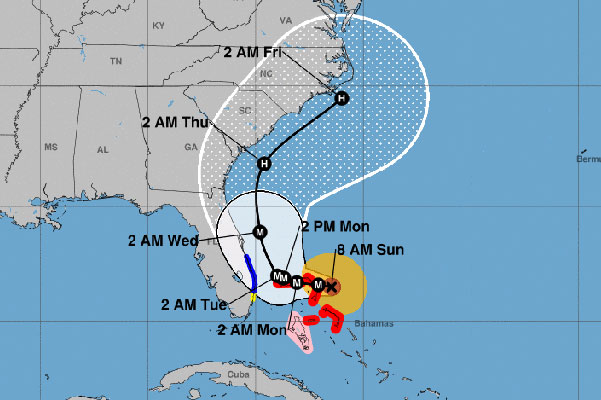
However, Dorian is could weaken back to the Category 4 while stalled over the Bahamas. The hurricane is expected to turn north in about two days, according to the National Hurricane Center.
While Dorian is moving west, it does not change the current projected path released at 5:00 a.m. and 8:00 a.m. this morning. This west movement was already included in the cone of uncertainty. Impact from the storm has not moved farther inland past the current projected path/cone.
Dorian’s path shifted slightly west overnight, but not enough to change the forecast. Dorian’s projected path is still expected to remain offshore from Florida at this time. However, please be prepared and finish all hurricane preparations incase this storm changes direction again.
“In 2 to 4 days, Dorian should turn northward in response to a trough over the eastern United States. By the end of the period, the flow on the south side of the trough should cause the cyclone to move northeastward near the Carolinas,” The National Hurricane Center said.
The latest EURO model shows Dorian tracking north after the Bahamas, sparing Florida. Most of the models show this same pattern except for the American GFS model. The GFS shows Dorian tracking a little more west of the Bahamas before going north, which would increase the wind speeds and bring potential hurricane watches to Sebastian.
So far, the EURO model has been more accurate, but these models are not a forecast.


Please continue to prepare for Hurricane Dorian. Do not remove your shutters until the storm has passed. Make sure you have plenty of water, food, and medication to last seven days. Board up any windows and listen to the advice given by emergency officials.
There are no mandatory evacuations in Indian River County. Brevard County mandatory evacuations have been postponed until Monday at 8:00 a.m.
Dorian is still a very dangerous hurricane and should still be taken very seriously. Although we feel the projected path will not change much, and confident that Sebastian will not get this hurricane, Dorian has already pulled many surprises. The route for Dorian has been challenging to predict.


Sebastian is still in the cone of uncertainty by the National Hurricane Center. We can expect high winds, rain, storm surge, and potential flooding. Sebastian could be hit with extremely high winds as shown in the maximum wind speed chart. This can also change again by Tuesday.
As a reminder, all Indian River County beaches are closed until further notice.
For now, all we can do is wait. We will have more information later tonight. Until then, please remain calm.
Our next forecast will be after 11:00 a.m. when we receive new information from the National Hurricane Center.
Stay tuned for more updates. We will be LIVE on our SebastianDaily.com website, Facebook, and YouTube all weekend at various times.

