
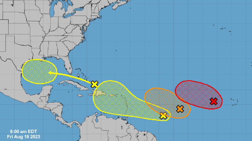
The Atlantic Ocean currently has four tropical disturbances, with the possibility of one advancing toward the Gulf of Mexico by next week. At this time, Florida doesn’t seem to be in the immediate danger zone.
The National Hurricane Center (NHC) advises those near Florida’s coastline to stay updated on these brewing storms.
Eastern Tropical Atlantic (AL98)
The foremost disturbance, designated AL98, is emerging in the Eastern Atlantic. This system, currently several hundred miles west of the Cabo Verde Islands, is exhibiting early signs of organization.
The NHC reported: “Environmental conditions appear generally favorable for additional development of this system, and a tropical depression is likely to form over the weekend while it moves toward the west-northwest or northwest at about 10 mph across the eastern tropical Atlantic.
However, by the start of next week, increasing upper-level winds may hinder its further development. It has a 70% likelihood of formation over the forthcoming week.
Central Tropical Atlantic (AL99)
The second system, producing scattered showers and storms, is positioned between the Cabo Verde Islands and the Lesser Antilles. Despite only marginally conducive environmental conditions, there’s still a chance it could develop into a tropical depression in the coming days.
Its trajectory is west-northwest at speeds between 10 to 15 mph. Upper-level winds are projected to turn unfavorable; its formation probability over the next week is 40%.
East-Southeast of the Lesser Antilles
A potential third disturbance might evolve from a stretched trough of low pressure located several hundred miles east-southeast of the Lesser Antilles.
The NHC suggests, “Some slow development of this system is possible over the weekend and into early next week as it moves generally west-northwestward at 10 to 15 mph across the Lesser Antilles and into the northeastern Caribbean Sea.”
It carries a 30% formation chance in the week ahead.
Western Gulf of Mexico
The last disturbance is near Hispaniola’s northern region and is projected to reach the Gulf of Mexico by next week, where a significant area of low pressure might emerge.
As per the NHC, “Some slow development of this system is possible thereafter as it moves westward and approaches the western Gulf of Mexico coastline by the middle of next week.”
This disturbance carries a 30% chance of formation in the next week. Nonetheless, forecasters are closely tracking its potential for reorganization as it progresses towards the Gulf of Mexico by week’s end.
Continued Updates
Sebastian Daily will persistently offer updates on these disturbances to inform residents living in Indian River and Brevard Counties. Keep an eye out for further information.

